|
Machu Picchu
|
We spent some time before we got here wondering if it could possibly live up to the hype, but, believe me, it does. The first link below shows you what we saw on our first evening at the site, coming to the Inti Punktu, or Sun Gate, after a strenuous day of hiking. The Gate is quite a ways from the main complex of Machu Picchu, so there is a good deal of scenery and views of the site that made for great photos along the way. These pictures are all included on the Inti Punktu page. The second link gives you the views we saw early the next morning when Hernán, our very well-informed guide, took us on a little side trip to the Inka Bridge, which is "around the corner," on the west side of Machu Picchu Mountain, from the main complex. We saw some beautiful scenery on the walk, as well as the interesting Bridge itself, so we are glad that he wanted us to see it. The the third link is a collection of pictures Henry took while climbing Waynapicchu, the impressive peak that makes the background of so many standard photos of Machu Picchu. (It can also be spelled Huana Picchu or Huayna Picchu, but I opted for the spelling on the signs at the mountain.) The remaining links will show you all the other photos taken at the Machu Picchu complex, divided up by general category. |
 |
Some Machu Picchu background information: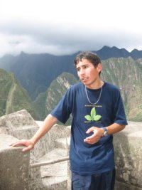
Its construction was probably begun in the 15th century, with improvements continuing until the Spanish conquest of the Inkas in 1530. Current archeological theory believes it was a sort of resort for Inka royalty, reachable from Cusco via the Inka Trail. Many of the various Inka sites in the Sacred Valley and on the Inka Trail were waystations used by those commuting from the capital to Machu Picchu for some R&R.
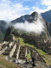
The Machu Picchu complex is at about 8,000 feet in elevation, considerably, and noticeably, lower than Cusco's 11,000. It is nestled between Machu Picchu and Waynapicchu Mountains and is surrounded on three sides (1500 feet below) by the Urubamba River. The mountains nearby are geologically fabulous, with sheer sides and impressive peaks, and the vegetation is lush. To people like us who are used to mountains in the dry American west it is a very exotic setting.
With help from local indigenous people, the American explorer Hiram Bingham "discovered" Machu Picchu, considerably overgrown with jungle foliage, in 1911. His photographs and articles in National Geographic acquainted the world with this amazing place.
Much of the foregoing information, as well as a good deal of the details of names, etc., on these pages, is from a guidebook loaned to us by Marina Rizo-Patrón (thanks, Marina!): The Machu Picchu Guidebook; a self-guided tour, by Ruth M. Wright and Alfredo Valencia Zegarra. Of course, we also learned a lot about the site from our wonderful guide, Hernán Yepez, shown here explaining some finer archeological points to us.
All photos, unless otherwise credited, are © by Henry J. Amen III. Please do not use without permission.